general situation
today
Friday 19 April
release: 18-04-2024 12:32 CEST
| average temp. at 1000 m (°C) | 5 | |
| average temp. at 2000 m (°C) | -1 | |
| prob. of widespread precipitations (%) | - | |
| thunderstorms probability (%) | 10 | |
| thermal zero height (m) | 1500 | |
| snowfall level (m) | - | |
| mean wind speed & direction at 2000 m (m/s) | W 6 | |
| mean wind speed & direction at 3000 m (m/s) | W 6 | |
| temperature (°C) | min | MAX |
|---|---|---|
| Claut | -1 | 13 |
| Piancavallo | -4 | 4 |
| 4 | 12 | 20 | |
|---|---|---|---|
| diurnal evolution |
 |
 |
|
tomorrow
Saturday 20 April
release: 19-04-2024 13:24 CEST
| average temp. at 1000 m (°C) | 6 | |
| average temp. at 2000 m (°C) | -1 | |
| prob. of widespread precipitations (%) | 70 | |
| thunderstorms probability (%) | 50 | |
| thermal zero height (m) | 1600 | |
| snowfall level (m) | 1000-1200 | |
| mean wind speed & direction at 2000 m (m/s) | N 6 | |
| mean wind speed & direction at 3000 m (m/s) | N 10 | |
| temperature (°C) | min | MAX |
|---|---|---|
| Claut | 1 | 14 |
| Piancavallo | -2 | 6 |
| 4 | 12 | 20 | |
|---|---|---|---|
| diurnal evolution |
|
 |
|
the day after tomorrow
Sunday 21 April
release: 19-04-2024 13:24 CEST
| average temp. at 1000 m (°C) | 5 | |
| average temp. at 2000 m (°C) | -3 | |
| prob. of widespread precipitations (%) | 50 | |
| thunderstorms probability (%) | 70 | |
| thermal zero height (m) | 1400 | |
| snowfall level (m) | 1000-1200 | |
| mean wind speed & direction at 2000 m (m/s) | NE 6 | |
| mean wind speed & direction at 3000 m (m/s) | NE 6 | |
| temperature (°C) | min | MAX |
|---|---|---|
| Claut | -2 | 11 |
| Piancavallo | -4 | 3 |
| 4 | 12 | 20 | |
|---|---|---|---|
| diurnal evolution |
 |
|
|
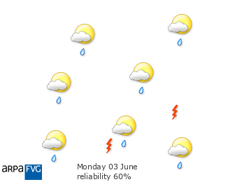
trend for MondayMon
Monday 22 April
release: 19-04-2024 13:25 CEST
| 4 | 12 | 20 | |
|---|---|---|---|
| diurnal evolution |
|
|
|
trend for TuesdayTue
Tuesday 23 April
release: 19-04-2024 13:25 CEST
| 4 | 12 | 20 | |
|---|---|---|---|
| diurnal evolution |
|
 |
|
